Moving map |
Post Reply 
|
| Author | |
vx800 
Check-In Staff 
Joined: 27 Jun 2015 Location: mail Points: 24 |
 Post Options Post Options
") Thanks(0) Thanks(0)
 Quote Reply Quote Reply
 Topic: Moving map Topic: Moving mapPosted: 02 Aug 2015 at 4:41pm |
|
Hi
I am not very impressed with the moving map in Tornado GR1, it is useless for navigation, I have even experianced that when taking of from Marham and flying North, over Water, the map shows that I am flying over land so the update is not working Why not take a look at Flying Stations Buccaner S1 and 2, it has an ok moving map (much more detailed than the map in Tornado GR1) in the backseat, which can be used for navigation or telling you where you are Ole |
|
|
vx800
|
|
 |
|
|
Rich
Just Flight Staff 

Joined: 31 Mar 2008 Location: Planet Earth Points: 8543 |
Post Options
Thanks(0)
Quote Reply
Posted: 02 Aug 2015 at 8:37pm |
|
The map is reading FS date. Have you perhaps installed 3rd party scenery that replaces land class information?
|
|
 |
|
|
|
|
vx800
Check-In Staff
Joined: 27 Jun 2015 Location: mail Points: 24 |
Post Options
Thanks(0)
Quote Reply
Posted: 02 Aug 2015 at 9:14pm |
|
I did have an ORBX installation but now, after I have installed my FSX Again to clean it up, the map shows exactly the same, just brown land and blue Water, no details and also it is not updated, meaning that even if I fly over Water it still shows that I am over ground/land
Ole |
|
|
vx800
|
|
|
|
|
sthenion
Check-In Staff
Joined: 18 Jul 2015 Points: 18 |
Post Options
Thanks(0)
Quote Reply
Posted: 06 Aug 2015 at 12:20am |
|
I agree. Map is essentially non functional. A good nav map/display was one feature I was hoping for. I like to be able to at least see airports...navaids, mileage arc etc. would be nice too. Since it uses resources I just turn it off.
|
|
|
|
|
vx800
Check-In Staff
Joined: 27 Jun 2015 Location: mail Points: 24 |
Post Options
Thanks(0)
Quote Reply
Posted: 07 Aug 2015 at 8:10pm |
|
Hi
It is not a big issue, just hope that in some later SP that there will be a useful moving map, looking forward to see what just flight comes up with Ole |
|
|
vx800
|
|
|
|
|
kevinh
P/UT 
Joined: 12 Nov 2008 Points: 211 |
Post Options
Thanks(0)
Quote Reply
Posted: 10 Aug 2015 at 12:15pm |
I don't think it's a land class issue as my scenery is mostly
default. It seems to be to do with how the graphic data is translated
before display in the gauge. I was flying south directly towards the
Needles (according to the map) and the Isle of Wight appeared to be
shifted a few miles east (visually). I carried on south a few miles then
turned back north towards the IOW. The moving map showed me as flying
over land! I was very definitely feet wet. Huge position errors are
appearing with heading changes.
Note, the TFR correctly indicated the cliffs as I flew over the IOW. Kevin |
|
|
|
|
Rich
Just Flight Staff
Joined: 31 Mar 2008 Location: Planet Earth Points: 8543 |
Post Options
Thanks(0)
Quote Reply
Posted: 12 Aug 2015 at 9:48pm |
|
Hi chaps,
Kevin, Ole - the map positioning should be fixed in the next service pack. sthenion, in the next update you'll be able to use the left TV screen to configure the map to show things like the magenta line, airports, VORs, NDBs, ILSs, intersections and airspaces. 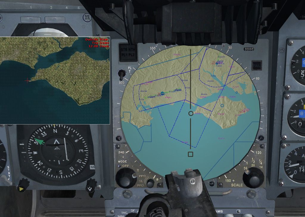 |
|
|
|
|
|
|
|
kevinh
P/UT
Joined: 12 Nov 2008 Points: 211 |
Post Options
Thanks(0)
Quote Reply
Posted: 12 Aug 2015 at 10:37pm |
|
Hi Rich,
Good to know, thanks. Kevin |
|
|
|
|
sthenion
Check-In Staff
Joined: 18 Jul 2015 Points: 18 |
Post Options
Thanks(0)
Quote Reply
Posted: 13 Aug 2015 at 3:52am |
|
Beautiful...thank you
|
|
|
|
|
vx800
Check-In Staff
Joined: 27 Jun 2015 Location: mail Points: 24 |
Post Options
Thanks(0)
Quote Reply
Posted: 13 Aug 2015 at 12:03pm |
|
very nice, looking forward to that
it would be a good fit for the Tornado Ole |
|
|
vx800
|
|
|
|
|
Post Reply
|
|
 Tweet
Tweet
|
| Forum Jump | Forum Permissions You cannot post new topics in this forum You cannot reply to topics in this forum You cannot delete your posts in this forum You cannot edit your posts in this forum You cannot create polls in this forum You cannot vote in polls in this forum |


 Topic Options
 Rich wrote: